Phase I Archaeological Survey of the Northington and Municipal Center Blocks
Principal Investigator
Marley R. Brown III
Colonial Williamsburg Foundation
Department of Archaeological Research
April 30, 1996
Re-issued
November 2003
Management Summary
Between April 2 and April 15, 1996 the Colonial Williamsburg Department of Archaeological Research conducted a Phase I archaeological survey within the Northington and Municipal Center Blocks of Williamsburg, Virginia. The main focus of the survey was to identify any archaeological resources in the areas threatened by planned construction.
Phase I shovel tests and exploratory trenching identified a single site qualified for additional investigation. This site is located on the Northington Block, west of the Cary Peyton Armistead house. The site contains both artifacts and intact stratigraphy from both the eighteenth and nineteenth centuries. Several outbuildings related to nineteenth-century Wheatlands were discovered including a dairy foundation and a well. The eighteenth-century component includes features, artifact concentrations, and sheet refuse.
A Phase II excavation is recommended for Site 1 if construction plans threaten this site.
ii Figure 1. Overlay of maps from the twentieth-century showing project area.
Introduction
The Colonial Williamsburg Department of Archaeological Research conducted a Phase I archaeological survey of a two city block area in Williamsburg, Virginia referred to respectively as the Northington Block and Municipal Center Block. Both blocks are bordered by Scotland Street to the south and Lafayette Street to the north. The Northington Block is bounded on the east by North Henry Street, while the Municipal Center Block's west boundary is Armistead Street. North Boundary Street divides the blocks.
The purpose of the survey was to determine the presence of any archaeological remains in the area threatened by the upcoming construction of an underground parking facility. This assessment of the archaeological data will determine whether additional investigation is needed prior to planned construction. Documentary, cartographical, and previous archaeological research have all indicated this area has a good potential for the recovery of material relating to an eighteenth-century urban plantation. Recommendations for further testing and protection are provided in the conclusion of this report.
Property History
The parcel of land (lots 212-217) was first mentioned in a deed dated December 1, 1746 (Stephenson 1990:5- 7). The deed indicates that Thomas Corbin of Urbanna first leased the property from the trustees of Williamsburg in 1722. Corbin conveyed the property to a prominent lawyer named John Holloway in 1732. The deed goes on to say that Holloway named Augustine Moore, Thomas Jones, and William Robertson the executors of his estate before his death in 1734. Holloway's estate must have been in litigation for several years for Thomas Jones, the only surviving executor, finally sold the estate to Dr. John Amson in 1746 for 43 pounds. The deed indicates that "Houses, Outhouses, Edifices, Buildings, Yards, (and) Gardens" existed on the property at the time of sale (Stephenson 1990:5-7).
Robert Anderson and his wife, Ann, acquired the parcel from Dr. Amson's estate in July 1765. Three years later Mayor James Cocke of Williamsburg issued a statement "to remove the ill impressions which the breaking out of small pox in this city has probably made" (Stephenson 1990:10) . The mayor's proclamation directed that others showing the symptoms of the virus be taken to Robert Anderson's house for treatment. Mayor Cocke describes the Anderson property as being "in a retired part of the city" (Stephens in 1990:10).
Robert Anderson sold his urban plantation to Dr. James Carter in July, 1769 for 1143 pounds. Little is known about the Carter's occupation of the site beyond an event mentioned in a letter to an acquaintance in London. He reported that he sold sheep and cattle to a unit of the British Light Infantry under the command of Colonel Abercrombie (Stephenson 1990:12). He also allowed them to stay in his house in 1781. James and Hester Carter conveyed he property to William Holt later that same year.
Documents relating to William Holt's tenure of the property provide some indication of what the property may have looked like in the late eighteenth century. The teed of sale mentions "Houses, Buildings, Gardens, Orchards, Ways, (and) Waters" (Stephenson 1991:13).
Both the Desandrouins map and the Frenchman's map show buildings and gardens throughout the lots 212-217 (Figure 2). Finally, the ledger of Humphrey Harwood, a local builder, provides information specific to the types of structures located on Holt's urban plantation. The account book lists repairs made to the house, kitchen, dairy, smokehouse, ash house, and cellar between 1783 and 1784 (Stephenson 1990:15). Although William Holt owned several properties in Williamsburg, the entries in Harwood's account book probably refer to lots 212-217.
Holt's estate sold six lots of the Henry Street parcel to John Sewell in 1807. Sewell, in turn, conveyed the property to Henley Taylor in 1827. Holt's house was replaced in the 1840s by a home that became known as Wheatlands (see Figure 7). The original parcel formed by lots 212-217 appears to have remained intact until after the Civil War. Taylor's name disappears from the tax list in 1850 and the property passed through several owners in quick succession (Stephenson 1990:16-17). By 1900, at least three homes stood along 3 4 Scotland Street. Dr. John Henderson bought Wheatland from the O'Keefe family in 1907. Henderson continued to live there until his death in 1959. The Colonial Williamsburg Foundation acquired the property from the Henderson family in the 1960s. Wheatland, however, had deteriorated beyond repair by that time and had to be demolished in 1968.
 Figure 2. Overlay of eighteenth-century maps showing the project area.
Previous Archaeological Testing
Since 1992, a number of small scale Phase I and II investigations have been executed on specific lots within the Northington Block. Each of these archaeological projects identified an eighteenth-century occupation layer.
435 Scotland Street
At 435 Scotland Street, a Phase II archaeological testing was conducted in January of 1992. Information gathered from six test units placed within the parcel noted an intact eighteenth-century layer beneath the nineteenth-century plowzone. No further work was recommended unless existing structures or pavings be altered or removed.
413 Scotland Street
Phase I survey of 413 Scotland Street uncovered similar evidence in March 1995. Fourteen shovel tests defined an intact eighteenth-century layer containing a light scatter of artifacts present underneath a nineteenth-century plowzone. Based on the preservation of the eighteenth-century layer and number of period artifacts, Phase II excavations were recommended before any construction commenced on the lot.
320 North Henry Street
Phase II testings were conducted at 320 North Henry Street in June 1995 and February 1996. Excavations in June concentrated on the area projected for relocation of the Armistead house. Evidence uncovered a number of suspected features and stratigraphy relating to the eighteenth and nineteenth century. Foundation remnants of the house called Wheatlands (built in the 1840s by Henley Taylor) were identified. Suggestive of at least one renovation, the footings contained sand mortared bricks placed on top of earlier shell mortared bricks. No further work was recommended for the area tested, but the area to the north was designated as having the potential to produce more archaeological information relating to eighteenth-century occupation.
Testing continued in February of 1996 on the northern half of the lot. The presence of late eighteenth/early nineteenth century features and layers pointed to activities associated to William Holt between 1783 and 1784.
No additional work as recommended for this parcel, although investigations were advised for the area to the north prior to any ground disturbing activities. Al1 of the evidence gained through these excavations suggested that this area has a potential to yield more information about the eighteenth-century occupation of the property.
In conclusion, previous archaeological investigations indicate an intact layer containing features and a light scatter of eighteenth-century artifacts is present throughout the Northington Block. While the core of the colonial urban plantation had yet is be discovered, these surveys suggest the probable location and extent of preservation of eighteenth century archaeological evidence within the Northington Block.
6
 Figure 3. Previous archaeology on the Northington Block.
Methods
A Phase I archaeological survey was conducted from April 2 to April 15, 1996. The project was undertaken at the request of both Colonial Williamsburg Foundation and the City of Williamsburg and was designed to identify any archaeological remains in the area.
Areas tested within the Northington Block included all property owned by the Colonial Williamsburg Foundation not previously studied and the city owned portion of the block. To aid in recording, present property lines were used as a guide for testing (Figure 4). The Municipal Center Block was tested only in areas designated as being directly affected by future construction. Shovel tests were placed systematically throughout each lot at 10 meter intervals. Once testing of the block was completed, areas containing a concentration of eighteenth-century artifacts were again tested at 5 meter intervals. The location and attributes of surface features were noted. Those areas covered by modern structures or paving were not tested unless colonial artifacts were present in nearby undisturbed locations.
Each shovel test was approximately 35 centimeters in diameter and excavated to sterile subsoil with shovels and hand trowels. Stratigraphic soil profiles were recorded for each test unit. Each shovel test it was treated as a single context and sifted using a ¼ inch steel mesh screen. Soil texture, soil color (Munsell), depth, and inclusions were recorded for each stratigraphic level. All artifacts, regardless of age, were washed, labeled, and organized by shovel test unit. Recovered artifacts and pertinent documents are stored at the Colonial Williamsburg Foundation's Department of Archaeological Research. Cartographical research had indicated the Northington Block is a likely prospect for colonial archaeological remains. Two trenches, measuring 1 meter in width by approximately 10 meters in length, were excavated using a Case Model 580 Super E backhoe and straightedge bucket at 350 North Henry Street. The trenches were necessary to identify any intact stratigraphy that may warrant further investigation. Stratigraphic soil profiles were recorded from each trench.
8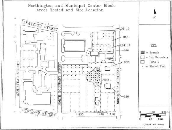 Figure 4. Location of shovel tests.
Results
Site 1, located west of the Cary Peyton Armistead house, contains both eighteenth-century and Wheatlands occupation periods. The site contains intact strata, some of which dates to the eighteenth century. While some of the eighteenth-century layer was damaged by the nineteenth-century intrusions, much remains intact.
Stratigraphy of the site is generally defined by three distinct layers: topsoil, Wheatlands layers/features which seal an olive brown sandy loam (Figure 5). This stratigraphic sequence plus the presence of eighteenth-century artifacts suggests this olive brown loam dates to the colonial period. Archaeological remains associated with the Wheatlands occupation include outbuilding remnants, a well, and intact stratigraphic layers. Both the well and outbuilding remains survived into the twentieth century and are depicted on a map of Williamsburg drafted in 1928 (Figure 6). Several photographs taken prior to the destruction of Wheatlands shows the various outbuildings that still stood in the 1960s (Figure 7).
A nineteenth century well associated with the Wheatlands occupation period was also found intact. Directly underneath the topsoil surrounding the well is a seemingly related stratigraphic layer comprised of crushed shell. The well was covered with a square modern brick cap consisting of three overlying brick courses joined with gravel mortar. Underneath the cap exists a circular brick lined well, the fill of which exceeds 2.62 m. A test unit in the well indicated the upper portion of the fill was modern.
A brick lined floor was revealed associated with the Wheatlands outbuilding known as the dairy. Measuring 3.5 m square, the outbuilding appears to have had a sunken floor joined by sand tempered mortar. Still attached to many of the bricks used in the foundation were remnants of shell tempered mortar still. This suggests the brick had been acquired from earlier structures possibly dating to William Holt's tenure of the property from 1781 to 1807.
Other foundation remnants affiliated with the nineteenth century were found north of the dairy. Intruding an eighteenth-century layer, a single course of sand mortared bricks were discovered on a north-south axis. It is currently unclear what this building was used for, but it appears to date to the nineteenth century.
Eighteenth-century occupation evidence is solely represented by the distribution and concentration of artifacts within an intact stratigraphic layer and two possibly eighteenth-century features. The loam layer contains brick flecks and charcoal inclusions and has been preserved throughout most of the site. Colonial period domestic artifacts ware found including green and blue shell edge pearlware, decorated Chinese porcelain, creamware, Whieldon ware, and stoneware. Other miscellaneous artifacts such as pipestems, wine bottle glass, and architectural debris combine to indicate this site was occupied during Dr. James Carter or William Holt's possession of the property in the late eighteenth century. Area A contained a high concentration of artifacts. Datable artifacts indicate this area was used during the late eighteenth/early nineteenth century during Holt's and Henley Taylor's tenure.
10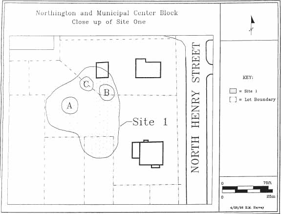 Figure 5. Site 1 boundaries and activity areas.
 Figure 6. Early twentieth-century map showing Wheatland outbuildings.
 Figure 7. Photo of some of Wheatlands outbuildings.
The testing of Area B revealed a subsurface trench containing brick rubble and any fragments of shell tempered mortar. The stratigraphic position and the presence of shell tempered mortar suggests this feature may date to the eighteenth century.
In Area C a thin lens of fossilized shell resembling a pathway sealed an intact eighteenth- century layer containing no artifacts or inclusions. The shell feature was sealed by a nineteenth-century plowzone and appeared to date to the eighteenth century.
Exploratory Trenching
Two trenches were excavated in an unpaved parking area located at 350 North Henry Street. Using cartographic sources, this area was suspected as having a high potential for containing a colonial urban plantation site. Trenching uncovered an early twentieth-century foundation and two stratigraphic layers. The top layer dated to the twentieth century. The bottom layer contained no cultural material. No further work is necessary in this area.
Recommendations
The purpose of this survey was to determine the archaeological resource potential threatened by the future construction plans for the Northington and Municipal Center Blocks.
Site 1
This portion of the Northington Block consistently contained evidence associated with both an eighteenth-century plantation and the nineteenth-century Wheatlands. Remnants of some of the Wheatlands outbuildings have survived, and should be recorded before any construction is underway.
Thirty shovel tests uncovered an intact occupation layer containing mostly late eighteenth-century domestic artifacts. This artifact concentration suggests that both colonial activity areas and eighteenth-century foundation remnants may exist in this area. In addition, two landscape features that appear to date to the eighteenth century were also uncovered.
Based on the results of this survey, additional archaeology is necessary to determine the site's limits, preservation, and significance. This can best be achieved by a Phase II testing of the site. We recommend systematically placed one meter square test units be excavated throughout the site at ten meter intervals. Using this formula, it will take fourteen excavation units to properly cover the site. Recovered artifacts would be washed, identified, and stored at the Department of Archaeological Research. A summary of the finding would immediately be distributed to both the city and the foundation.
Bibliography
- 1781
- Carte des Environs de Williamsburg en Virginie on les Armes Francoise et Americaines ont Campes en Septembre 1781. Photostat on file. Special Collections, Colonial Williamsburg Foundation Library. Williamsburg, Virginia.
- 1782
- Plan de la Ville et Environs de Williamsburg en Virginia, 1782. Photostat on file. Special Collections, Colonial Williamsburg Foundation Library. Williamsburg, Virginia.
- 1990
- "Block 36, Lot 212-217 Historical Report." Originally printed in 1961 under the title "Colonial Lots 212-217 Block 36." Colonial Williamsburg Foundation Library Research Report Series 1620. Colonial Williamsburg Foundation Library. Williamsburg, Virginia.
- 1928
- Map of Williamsburg, Virginia: Restoration Survey. Revised 1930. Photostat on File. Special Collections, Colonial Williamsburg Foundation Library. Williamsburg, Virginia.